
H3 indexes for performance with PostGIS data
I recently started using the H3 hex grid extension in Postgres with the goal of making some not-so-fast queries faster. My previous post, Using Uber's H3 hex grid in PostGIS, has an introduction to the H3 extension. The focus in that post, admittedly, is a PostGIS focused view instead of an H3 focused view. This post takes a closer look at using the H3 extension to enhance performance of spatial searches.
The two common spatial query patterns considered in this post are:
- Nearest neighbor style searches
- Regional analysis
This post used the H3 v3 extension. See Using v4 of the Postgres H3 extension for usage in the latest version.
Setup and Point of Focus
This post uses two tables to examine performance.
The following queries add an h3_ix column to the osm.natural_point
and osm.building_polygon tables. This approach uses
GENERATED columns
and adds an index to the column. Going through these steps allow us
to remove the need for PostGIS joins at query time for rough distance searches.
See my
previous post for details about installing
the H3 extension and the basics of how it works.
Using Uber's H3 hex grid in PostGIS
This post explores using the H3 hex grid system
within PostGIS. H3 was developed by Uber and has some cool benefits
over the PostGIS native ST_HexagonGrid() function used
in my post Find missing crossings in OpenStreetMap with PostGIS.
The hex grid built-in to PostGIS is great for one-off projects covering a specific region,
though it has shortcomings for larger scale consistency.
On the other hand, the H3 grid is a globally defined grid that scales up and down
through resolutions neatly. For more details, read
Uber's description.
This post used the H3 v3 extension. See Using v4 of the Postgres H3 extension for usage in the latest version.
This post works through a few of the functions available in the H3 extension and how they can be used for spatial aggregation in an analysis. One additional focus is how to generate a table of H3 hexagons for a given resolution.
Note: This post does not focus on using H3 for the best performance. See my post H3 indexes for performance with PostGIS data for a look into high performance spatial searches with H3.
Install H3 in Postgres
The H3 library is available to PostGIS as a Postgres extension. I am using
the bytesandbrains h3-pg project
available on GitHub. The extension can be installed using
pgxn install h3. Once installed, create the H3 extension in the database.
CREATE EXTENSION h3;
Postgres Data Dictionary for everyone
A data dictionary is an important tool for anyone that stores and consumes data. The PgDD extension makes it easy to inspect and explore your data structures in Postgres. This post shows how PgDD provides access to current and accurate information about your databases for a variety of users:
- Analysts
- DBAs and Developers
- The Business
This data dictionary information from PgDD is made available using standard SQL by querying a small set of views.
Background
Relational databases, including Postgres, track the majority of the information
needed for a data dictionary. This is done in the underlying
system catalogs;
Postgres' system catalogs are in the pg_catalog schema.
The challenge with using the system catalogs is they are not very
user friendly to query for the type of details commonly needed.
PgDD does not do anything magical, it is simply
a wrapper around the Postgres system catalogs!
Permissions required for PostGIS
PostGIS is a widely popular spatial database extension for Postgres.
It's also one of my favorite tools!
A recent discussion on the People, Postgres, Data
Discord server highlighted that the permissions required for various PostGIS
operations were not clearly explained in the PostGIS documentation.
As it turned out, I didn't know exactly what was required either.
The basic PostGIS install page provides resources
for installing the binary on the server and the basic CREATE EXTENSION commands,
but does not explain permissions required.
This post explores the permissions required for three types of PostGIS interactions:
- Install/Create PostGIS
- Use PostGIS
- Load data from
pg_dump
Database and Users
I am using Postgres installed on my laptop for these tests, Postgres 13.5 and
PostGIS 3.1.
I created an empty database named postgis_perms and check the \du
slash command in psql to see the current roles. This instance has my
my ryanlambert role, a superuser, and the default postgres role.
The postgres role is not used in this post outside of this example.
([local] 🐘) ryanlambert@postgis_perms=# \du
                                     List of roles
┌─────────────┬────────────────────────────────────────────────────────────┬───────────┐
│  Role name  │                         Attributes                         │ Member of │
╞═════════════╪════════════════════════════════════════════════════════════╪═══════════╡
│ postgres    │ Superuser, Create role, Create DB, Replication, Bypass RLS │ {}        │
│ ryanlambert │ Superuser, Create role, Create DB                          │ {}        │
└─────────────┴────────────────────────────────────────────────────────────┴───────────┘
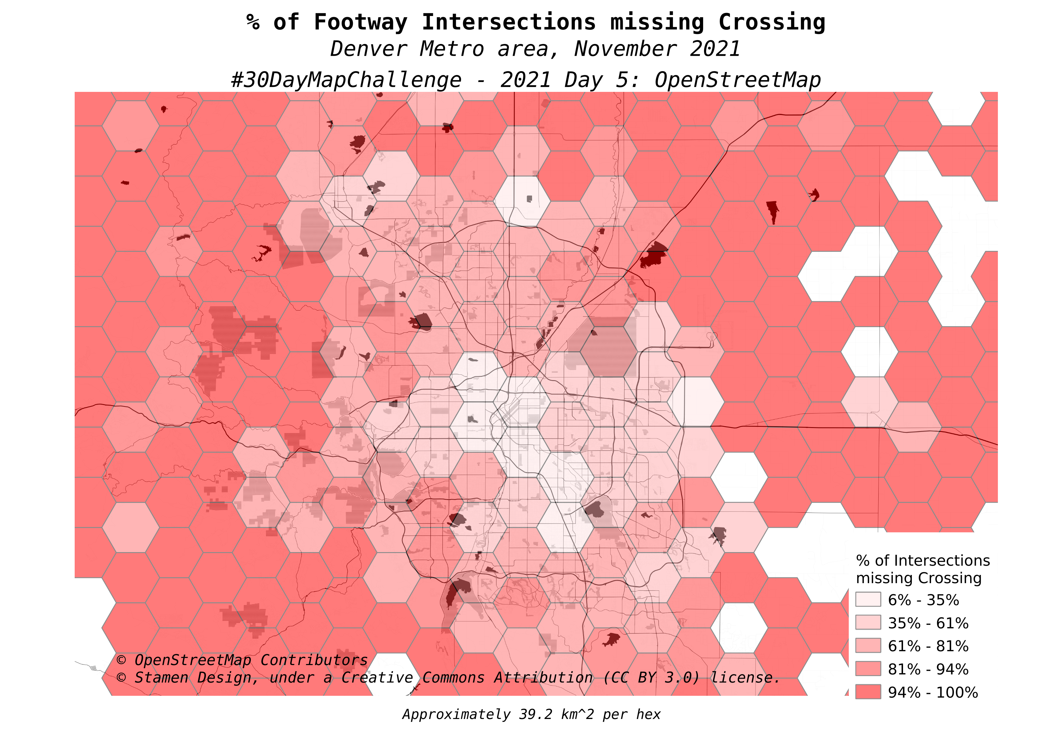
Find missing crossings in OpenStreetMap with PostGIS
The #30DayMapChallenge is going on again this November. Each day of the month has a different theme for that day's map challenge. These challenges do not have a requirement for technology, so naturally I am using OpenStreetMap data stored in PostGIS with QGIS for the visualization component.
The challenge for Day 5 was an OpenStreetMap data challenge.
I decided to find and visualize missing
crossing tags.
Crossing tags are added to the node (point) where a pedestrian
highway (e.g. highway=footway) intersects a motorized highway
(e.g. highway=tertiary).
This post explains how I used PostGIS and OpenStreetMap data to
find intersections missing a dedicated crossing tag.
Without further ado, here was my submission for Day 5.
 Mastodon